Advanced Algorithms for Real-Time, Sub-Meter Precision Distance Measurement Using UWB Technology
2024-10-29
Unlike Bluetooth, which operates at 2.4 GHz, and Wi-Fi, which functions at both 2.4 GHz and 5 GHz, Ultra-Wideband (UWB) technology utilizes 6 ~ 8 GHz frequency spectrum. As the frequency increases, the signals tend to have shorter propagation ranges and reduced ability to penetrate walls and other obstacles, which can limit the effective range of UWB signals.
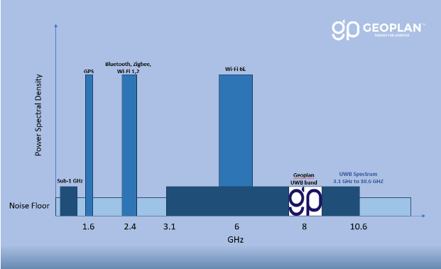
Source: Geoplan, Designed by Geoplan
TWR
Two Way Ranging (TWR) in Ultra-Wideband (UWB) technology measures the distance between two nodes by sending a signal from one node to another and calculating the time it takes for the signal to travel to and return from the second node. This round-trip time, multiplied by the speed of light, provides the distance between the nodes. TWR is known for its high accuracy and robustness, making it ideal for applications that require precise distance measurements, such as asset tracking and indoor navigation.
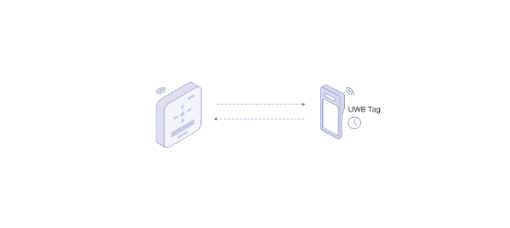
Source: Geoplan, TWR
TDoA
Time Difference of Arrival (TDoA) in UWB technology determines the location of a device by measuring the time differences between when a signal from the device arrives at multiple fixed anchor points. By calculating these time differences and using the known positions of the anchors, the system can accurately triangulate the device’s position. TDoA is particularly effective in environments with multiple devices and anchors, providing high-precision location data for applications like asset tracking and personnel monitoring.
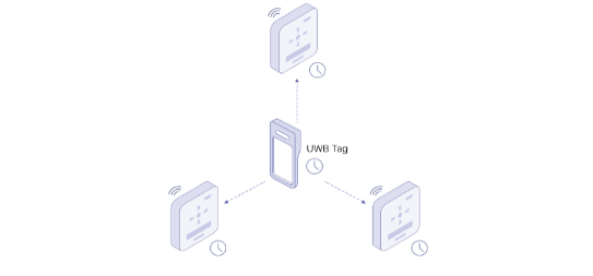
Source: Geoplan, TDOA
AoA
Angle of Arrival (AoA) in Ultra-Wideband (UWB) technology is a positioning technique that determines the direction from which a signal arrives at an anchor or receiver. This is achieved by measuring the phase or time differences between signals received by multiple antennas at the anchor. By calculating these differences, the system can accurately determine the angle of arrival of the signal. AoA provides precise directional information and can be used in conjunction with other methods, such as Time Difference of Arrival (TDoA), to enhance overall positioning accuracy. It is particularly useful in applications requiring detailed orientation or movement tracking, such as indoor navigation, sports performance analysis, and robotics.
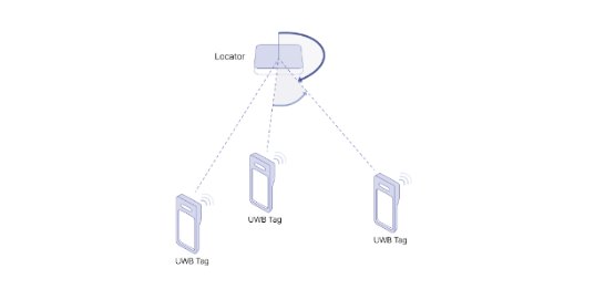
Source: Geoplan, AoA
UWB RTLS System Flow
The UWB RTLS process begins with UWB tags or UWB-enabled smartphones emitting signals, which are captured by strategically placed locators. These locators, synchronized by a sync unit, transmit the signal data to the RTLS platform, where the precise location of the tags or smartphones is calculated. This location data is then sent to the RTLS server, which manages and stores it for various applications, such as indoor navigation, asset tracking, smart building safety, and security. The data can also be utilized for advanced services like digital twins, AI, AR, and VR. Users can access this information via mobile applications, while management applications allow for system control and monitoring.
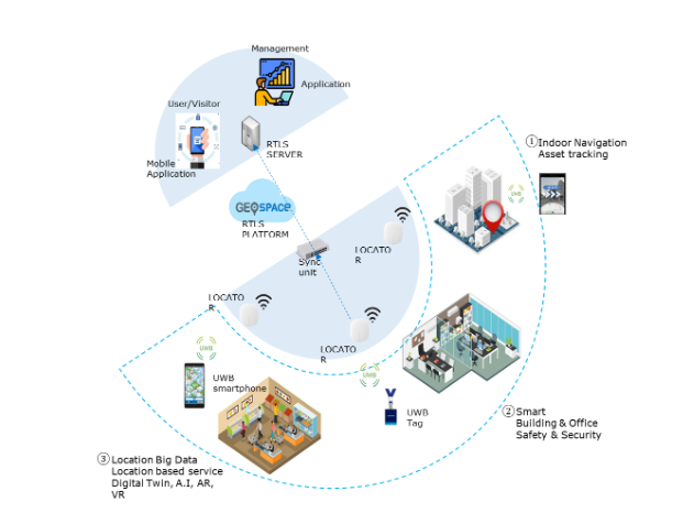
Source: Geoplan, UWB RTLS process starting from UWB tag and ending with User application
News&Blog
